History
Earthquake measurement in Hamburg since 1898
The Wiechert Seismograph | ||
|---|---|---|
 |
 |
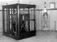 |
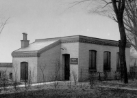
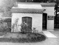
| Imperial Main Station for Earthquake Research in Jungiusstrasse in Hamburg around 1905 | ||
The Hamburg Earthquake Observatory grew out of a private collection of its founder Richard Schütt. The first horizontal seismograph (Rebeur Ehlert) was put into operation on 17 July 1898 on his private property in Hohenfelde. In 1903, the station was put into international service as one of eight main imperial stations for earthquake research. For this purpose, Schütt had an earthquake station built for the second time (approx. 60,000 Reichsmark), this time in the Jungiusstraße. He handed over the station with all the necessary instruments and fully operational equipment (horizontal pendulums Rebeur-Ehlert and Hecker, Wiechert seismograph, as well as two astronomical clocks by Riefler) to the Oberschulbehörde as free state property. Furthermore, he took over the personnel and operating costs for the earthquake observatory and the publication of the "Communications from Hamburg Station". The Earthquake Observatory was a department of the State Physical Laboratory and was the forum of geophysical academic life in Hamburg. With the founding of the university in 1919, the earthquake station became part of the geophysics department at the University of Hamburg. The highly sensitive station recorded earthquakes until the 1980s and is currently on display in the foyer of the Geomatikum.
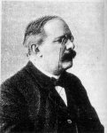 |
Richard Schütt, merchant (1864-1943): |
 |
Emil Wiechert, professor (1861-1928): |
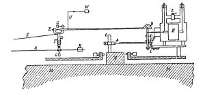
Measuring principle of the inverted horizontal pendulum:
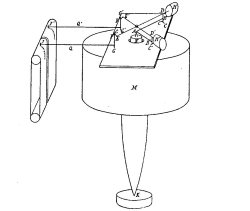 |
The seismograph works like an inverted pendulum. The mass (M) of one tonne remains at rest while the frame moves with the ground. Two small leaf springs (C) keep the mass in balance. The air damping (piston H) suppresses the natural resonances. The seismograph amplifies the ground movement by a factor of 200 via a linkage before it is recorded via a recording arm (Q). An inclination of the mass of 1/3600 degrees produces a needle deflection of 24 mm. Recordings were made on soot paper with a regular paper feed, the time being controlled by astronomical clocks. |
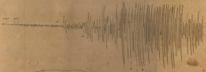
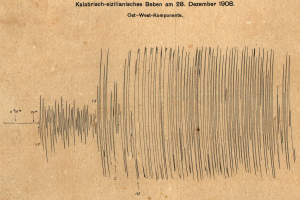
Historical quake records in Hamburg on soot paper
 |
 |
|
Earthquake near Messina, 28 Dec 1908, |
Earthquake in Iran, 23 Jan 1909, |
We have an archive with analog seismograms dating back to 1906. If you are interested in using any for your research, please contact Prof. Dr. Celine Hadziioannou.
Horizontal pendulum station
This was Richard Schütt's private earthquake observatory in Hohenfelde. It was in operation from 1898 until Nov. 1905.
Data:
Geographical latitude: 53° 33' 55'' N
Geographical longitude: 10° 01' 19'' E
Height: 15 m ü. NN
Seismometer: 3 Horizontal pendulum Rebeur-Ehlert, 80x magnification
Main station for earthquake research
Nov. 1905 until June 1942, Jungiusstrasse
Data:
Geographical latitude:  53° 33' 33'' N
Geographical longitude:  9° 58' 52'' E
Height: 14,9 m ü. NN
Seismometer:  horizontal Pendulum Hecker V=32
                          Wiechert horizontal V=190
                          Wiechert vertical V=200 ab 1912
The station in Hamburg-Harburg
From 1954 to 1997, the Hamburg earthquake station was located in Harburg. Wiechert's seismograph was in operation there until the 1980s. From 1975, it was supplemented by a more modern device. With the completion of the nearby A7 motorway and the heavy traffic rolling on it, the unrest in the ground and the associated vibrations became too great. The new home was finally found in the lime caves of Bad Segeberg.
Data:
Station's code:            HAM
Geographical latitude    53° 27' 54'' N
Geographical longitude:       9° 55' 29'' E
Height:                     30,2 m ü. NN
Seismometer:             Wiechert horizontal and vertical
                          Mars 3-Components ( 1975-1997 )
The new station in Bad Segeberg
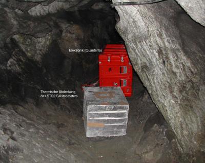
The new earthquake station has been located in Bad Segeberg since 1995, at the bottom of the Bad Segeberg cave, isolated from man-made noise. This station is part of a network of modern stations, the German Regional Network (GRSN - German Regional Seismic Network). The GSRN is able to register seismic waves from damaging earthquakes worldwide and to locate these quakes quickly.
The station in Bad Segeberg continuously "listens" for earthquake waves from distant, but also from local earthquakes. "Live"-Seismograms of this station can be found here.
Data:
Station's code:            BSEG
Geographical latitude:      53° 56' 7,1'' N
Geographical longitude:       10° 19' 0,8'' E
Height:                     40 m ü. NN
Seismometer:              Streckeisen STS-2
Frequency range:          0.0125 Hz < f < 40 Hz

